 As I flew
to Salt Lake City on a sunny yet cloudy Saturday afternoon in mid-April, I was
both excited and nervous — excited because I had a full week of nothing but
hiking in front of me. No work. No Facebook. No sports. Nothing else. And
that’s why I was nervous, too. Not only was I adventuring to an area of the
country that I’d never explored — Arches and Canyonlands national parks in the
southeastern quadrant of the state — but I faced the challenge of disconnecting
entirely from my normal life and not driving myself crazy.
As I flew
to Salt Lake City on a sunny yet cloudy Saturday afternoon in mid-April, I was
both excited and nervous — excited because I had a full week of nothing but
hiking in front of me. No work. No Facebook. No sports. Nothing else. And
that’s why I was nervous, too. Not only was I adventuring to an area of the
country that I’d never explored — Arches and Canyonlands national parks in the
southeastern quadrant of the state — but I faced the challenge of disconnecting
entirely from my normal life and not driving myself crazy.
This
wasn’t my first solo hiking trip. In the past couple years, I had spent a few
days by myself in Colorado and Maine climbing mountains. But those trips were
different in that I had specific goals to achieve — climbing Colorado’s 14ers
and Maine’s 4,000-footers. I knew what I needed to do. They were hiking
missions. This Utah trip, on the other hand, featured no “mountains,” but
rather tons of canyons. There wasn’t much hiking up, but rather hiking down (at
least to start).
Other challenges
included the isolation (on many hikes, I walked for hours without seeing a
soul); the weather (it got down to the mid-20s on some nights and took awhile
in the mornings to warm; one day got snow); and keeping my mind occupied during
the long days (fortunately, I brought along three books that I finished during
the week).
By no
means was this an easy, leisurely vacation. Rather, it was an exciting,
uplifting challenge that not only presented me the opportunity to explore yet
another breathtaking American national park, but gave me hours upon hours to
think silly thoughts and deep thoughts — considering where I am in the world
and where I want to be.
By the
time I boarded a plane back to Washington, DC, eight days after arriving, I had
hiked 90.9 miles, spent eight (often restless) nights in my tent, seen dozens
of swooping ravens, walked over miles upon miles of slick rock, dry washes,
and, yes, snow, and gotten a nice tan.
Here’s my
day-by-day summary of the trip:
Saturday,
April 13
After
getting talked into a Ford Fusion by the rental car lady, stopping at Whole
Foods for water and other food items, stopping at REI for gas for my mini
stove, and driving four hours, I pulled into the Goose Island campground in
Moab around 8:15pm MST. The sky was almost completely dark.
Campgrounds
in the area are all first-come, first-served, and this campground on the banks
of the Colorado River just outside of the town and a couple miles from Arches
National Park looked to be full. But it was dark. It was late. And I was
exhausted, despite passing out cold on both of my flights from DC. I knocked
awkwardly on the trailer door of the camp host, and he stumbled out.
“Do you
have any room?” I lamely asked.
After
thinking it over, the older gentleman said he could ask people staying there if
I could snag a small portion of their group site. Minutes later, I was
attempting to set up my tent in a windstorm. As I got the poles erected, I
looked behind me and my sleeping bag had blown 10 feet closer to the Colorado.
Luckily, I avoided disaster on my first night and got some rest.

Sunday,
April 14
FUN
FACTS:
Miles
hiked: 13.2
People
seen: Hundreds
Weather:
Sunny, 60s
I awoke
to Dave, the host, outside my tent, saying that an actual campsite had opened
up where I could stay Sunday night. Awesome, I thought. I dragged my stuff to
site No. 3, paid the $15 (actually, I only had a $20, so Dave got a little tip
for his kindness), re-setup my tent, and got my stove out to cook some instant
oatmeal. After the water boiled and I dumped it into my small blue cup with the
oatmeal, I added raisins and dried cherries and stirred. This would be my
breakfast staple all week long. YUM!!
Then, it
was time for Arches.
With the
weather quickly heating, I made the short drive to the park and continued the
18 miles on the main drive — attempting to stay focused on the road while
gazing to my left and right at the beautiful red rock towers — to the trailhead
for the Devils Garden Primitive Loop, which starts by the Devils Garden
campground where I had been too late to the party to get a campsite reservation
for (it’s the lone car campground in the park).
Before
leaving Goose Island, I had organized my trip belongings in the Fusion, using
the backseat as a dresser for my clothes (shirts on one seat, shorts on
another, etc.) and the trunk as my pantry for food items and water. The
passenger seat was for my books, maps, hats, handkerchiefs, camera, and any
other necessities. This made preparing for each hike rather simple.
Ah, the
beauty of traveling alone!
After
gathering belongings and stuffing them in my Camelback, I headed out on the
7.2-mile loop trail that visits — if you take all the spur trails — seven
arches. The trail was mostly sandy, which I quickly learned because I was
wearing my trail running shoes that have breathing holes on the side and on top
and picked up sand as I went. Red canyon walls were a constant background on my
hikes, and Arches was no different.
There was
always something beautiful to look at. Dull moments hiking were few and
far between.
It’s hard
to describe the arches, but they were all different and offered something new
to look at. Some of them, like Landscape Arch, looked made of a thin strip of
rock, which, if you sat on it after a heavy lunch, you might break. Others,
such as Partition Arch, were more of a round hole in a sturdy rock canyon wall.
All the arches offered cool vantage points, which I tried to capture on camera.
In
between the arch-gazing, I took the spur for the Dark Angel, a pointy rock
spire at the northernmost spot of the trail and observed a few rock climbers
attempting to scale the very vertical structure (I still have no interest in
trying that!). When I turned around to return to the loop, I was treated to my
first view, although distant, of the La Sal Mountains, which would constantly
dominate the eastern horizon during my week. The snow-capped peaks are
highlighted by Mt. Peale, which rise to 12,726 feet. By contrast, most of my
hiking was between 5,000 and 6,000 feet.
As I
completed the loop, I was glad I had gotten a relatively early start, as the
Sunday tourist crowd was flowing in. Babies, Europeans. Those in jeans. Those
in baggy shorts. You name it — Arches was a zoo of activity on this beautiful
Sunday afternoon.
But my
day was far from over.
My next
stop was the Delicate Arch, a 1.5-mile hike to the east of the Primitive Loop.
The hike involved scampering up a large, gradually sloping dome of rock. As I
caught my breath, I passed dozens of hikers — a teenage school group, families
with toddlers, more babies. This seemed to be another popular spot. And
rightfully so.
After
navigating a narrow, but flat ridge bordered by a rock wall on the right and a
little drop-off on the left, I turned a corner and there, at the base of a
large, shallow bowl of slick rock, was the arch. It looked to be about 25 feet
tall and maybe 8 feet wide, standing elegantly and straight on the slick rock.
Behind it, in the distance, was the La Sal range. I attempted, as did the
dozens of others with cameras around me, to capture the arch with snow-capped
peaks within it. I then walked down into the bowl of rock to the arch for a
close-up examination of it. The arch looked pretty sturdy, not brittle, but
hey, that’s just my take.
Maybe
they named it “Delicate Arch” to keep tourists from banging on it. Just
kidding, folks.
As the
sun dropped in the sky, I did a couple more short hikes to fill the time —
including a hike to an overlook of Delicate Arch from the east, which provided
an interesting perspective of it from farther away, and, finally, a 2-mile
out-and-back of Park Avenue that clearly resembled the bustling street in New
York City minus all the noise. The trail that dropped down between towering
walls of red rock provided me my first complete tranquility of the trip, as I
was alone in the evening shadows — just the desert and me.
I would
experience a lot more of that in the coming days.

Monday,
April 15
FUN
FACTS:
Miles
hiked: 8.7
People
seen: 3
Weather:
Cloudy, rainy, 50s
I slept
well Sunday night at the Goose Island campground, not waking until almost 8am.
It was a good thing I pulled myself out of the tent at that point, because a
few minutes later it started to lightly rain.
I quickly
broke down my tent as much as I had to before stuffing it in the backseat, cooked
some oatmeal while I still could, scarfed that down, and hopped into the
Fusion. It was time to drive south to the Needles district of Canyonlands.
I made a
few stops in Moab on the way south, knowing it would be the last civilization
I’d pass through en route to the isolated section of the park. I picked up a
pillow that was on sale for $4.99 (I figured it would be a comfortability
upgrade from sleeping on my down jacket), I got some hot chocolate from the
7/11 (warm drinks are oh, so good when it’s cold out), and I lucked out when I
passed a Wells Fargo that allowed me to get cash needed to pay for camping
without paying an ATM fee.
Finally,
it was go time.
After
driving 50 miles south on 191, I came to the sign for 221 West and Canyonlands
National Park. Within the first mile of driving, I passed a sign that read
“Open Range.” A minute later I knew the meaning when I came upon a group of
cattle right on the side of the road. Don’t see that every day, do ya? Luckily,
they let me pass.
As I
continued on the 30 miles of driving on the desolate, curving road, I became
nervous — and not because of the cattle. I thought I might have made a big
mistake by not putting any gas in the car back in Moab. As the needle crept
toward the one-fourth-of-a-tank indicator, I wondered if I would be able to get
the car to Needles and back to Moab, three days later, without running out of
fuel.
I
seriously considered turning around, getting gas in Moab, and then heading to
Island in the Sky. Maybe I could do Needles later in the week.
Ultimately,
though, I’m a risk taker, and I continued on.
I was
saved any more anxiety when I came to the outskirts of the park and a sign for
Needles Outpost that indicated they had gas. As I drove down the dirt road, I
was a little skeptical. And I even wasn’t sure when I pulled up to the pump
that looked straight out of the 1950s.
Did this
thing really pump unleaded gas?
But the
lady inside assured me it did, and I proceeded to pump three gallons of $6.50
gas — and I couldn’t have been happier about it.
Minutes
later, I was driving within the Needles, heading toward Squaw Flat Campground —
an arrangement of car campsites close to all the trailheads in the hiking
district. The campsites were all first-come, first-served and pretty popular,
so I was also nervous about securing a site.
I got the
last one, No. 5, and filled out the slip of paper, indicating I’d be staying
for three nights. After slipping the envelope with $45 in the pay slot, I
attached the torn off piece of paper with my camping information (nights
staying, license place) to the wooden post at the base of my site and went
about setting up camp.
A little
after 11am, I was settled at my new home and ready to hike! The sky was
nebulous and it was chilly outside, so I picked a hike that wasn’t too long —
the 10-mile there-and-back to the Peekaboo campsite to the southeast of where I
was staying.
The first
couple miles of hiking were extremely easy, as I walked along a mostly dirt
path through grass and desert fauna. I passed a pair of older hikers stopped
for a snack, glad to see other people were on the same trail. Besides seeing
them, I felt like I had the wilderness to myself (even though I could see for
miles in all directions).
I then
reached the slick rock, a combination of grays and reds that I would become
very familiar with over the course of the week. I scampered up a steep slope of
rock, was hit with stiff winds, and then hiked delicately along the top of a
downward sloping wall of rock — the trail marked by small cairns.
After
navigating my way down the rock, I reached my first “dry wash,” a sandy,
beach-like path that fills up very quickly with water during the rainy, monsoon
season. While rain was threatening, I wasn’t too worried about a monsoon.
Hiking in the wash was easy — and I enjoyed the random yellow, red and lavender
wildflowers along the path — but I did get a lot of sand in my trail running
shoes that found its way through the ventilation holes in the tops of the
shoes.
After a
mile or so, I climbed back up to the slick rock and enjoyed an extended period
of horshoeing along the tops of narrow canyons. The scenery was incredible and
the footing was great. As long as the rock stayed dry, I wasn’t worry about
slipping, even when descending steeply.
But the
sky was ominous, and when I passed an unexpected fellow hiker, he responded to
my salutation with a grunted “good luck.” Hmm, I thought to myself. Am I doing
something stupid here? It still wasn’t raining, so I pressed on, hating the
thought of turning back on such a cool hike.
Awhile
later though, as I inched my way across a down sloping rock slab — which only
had a few feet to spare before a steep drop-off — and felt a few drops of rain,
I made the difficult decision. It was time to turn around. Peekaboo campground
would have to wait for my visit.
Of
course, the rest of the afternoon was beautiful. The few raindrops I felt on
the return trip quickly dissipated, and the sun came out. It was disappointing,
but I made the most of the remaining daylight hours.
First, I
drove to Pothole Point, a short 0.6-mile hike on slick rock where I found a
perfect reading spot and sat down in the sun surrounded by incredible beauty
and peacefulness. While I’m often the restless type, unable to sit still for
long periods of time, I was able to stay in this special place for over an
hour, actually dozing off for a couple minutes at one point.
It helped
that my book, “Wild” by Cheryl Strayed, was really good, too.
Later in
the afternoon, on the ranger’s recommendation, I drove to Cave Spring — another
0.6-mile loop that takes you past caves, up a ladder to an open rock cropping,
and then back down through a mini desert swarming with cacti to the parking
area.
I only
hiked about 8.7 miles Tuesday, but I felt I experienced a bit of everything. At
the very least, I had gotten my Needles appetizer — with the main course and
dessert in the desert still to come.
I headed
back to my campsite, boiled some water for soup and hot chocolate, and then
crept into my tent as darkness and the desert chill arrived at once.

Tuesday,
April 16
FUN
FACTS:
Miles
hiked: 16
People
seen: about a dozen
Weather:
Partly sunny, 60s
I woke up
at 6:30 a.m. on Tuesday already a bit cold with the wind howling outside my $69
Eureka one-person tent (one of the best buys I’ve ever made). I forced myself
out of the tent, blew on my hands in a futile attempt to warm them, then
scrambled up the slick rock behind my campsite for view of the sunrise while
attempting to eat breakfast. The wind caused my stove to go out twice, but I
finally got it going and hovered over the flame to protect it. I WANTED MY
OATMEAL!
The sun
rose close to 7 a.m., glowing, but the cold, windy conditions weren’t going
anywhere. It was early, but I wasn’t going to warm up sitting around. It was
time to make moves.
My hike
involved a 15.4-mile loop to the Druid Arch encompassing the Big Spring Canyon
Trail, Squaw Canyon Trail, Druid Arch Trail, and Elephant Canyon Trail.
I started
out hiking on a packed-down dirt path, wondering if the weather would behave to
allow me to finish a hike that would involve a lot of time in the dry wash. The
sky was gloomy, and the ranger I’d talked to the previous afternoon had
forecasted afternoon rain. With that in mind, I kept up a pretty good pace.
After a couple miles, it was time to shed the fleece, hat and pants, as I was
warm and about to hike up some slick rock. Quickly gaining elevation, I came to
a ladder up a steep rock wall. I couldn’t see anything but blue, cloudy sky
about it.
I felt
like I was climbing toward some sort of heaven.
In a way,
I was. I scrambled down the slick rock on the other side and took a minute to
gaze around me. Like the afternoon before, I was in a rock amphitheater,
surrounded by towering walls, spires, mounds — you name the shape. When I
looked down, there were the pine trees of the dry wash. There was so much to
look at!
Upon
reaching the junction with Squaw Canyon after 2.1 miles, the remaining 4.6
miles of walking was entirely in the wash — meaning lots of sand. One thing about
a trail in the dry wash is, it’s easy to find. Even if you miss a cairn or two,
you know where it’s going. Still, I was in an unfamiliar land and the cairns
gave me peace of mind. Seeing that next small pile of rocks let me know that I
was on the right track and that regardless of how desolate the desert canyon
seemed or how alone I appeared to be in such a expansive space, I knew exactly
where I was.
After
following cairns on the beach for awhile, I reached what appeared to be the
rocky ascent to Druid Arch. I passed two women descending and asked if I was
close. They replied that I was mere minutes away. They were right.
A couple
minutes later, I emerged from the loose rock hillside and gazed at, by far, the
coolest structure I’d seen all week (and that’s saying something, considering I
had visited Arches).
The Druid
Arch, tall and rectangular, featured a vertical opening of light on its left
side — from my vantage point — and a sliver of a opening on its right. It was
akin to a very oddly, but cool, designed window. I don’t know how else to
describe it.
I slung
off my Camelback, took out my rice crackers and sunflower seed butter, devoured
my lunch, read my book, got some sun, and basked in being in such a cool place.
Of
course, the sky back to the north and west still looked gloomy, so I didn’t
hang out forever. I still had 7 miles left to hike back to base camp. Others
apparently weren’t worried about possible rain, as I passed a couple groups of
people heading to the arch as I retraced the 2.5 miles in the dry wash to the
trail junction.
Finishing
the loop via the Elephant Canyon Trail, I met a camper at my final trail
intersection with whom I chatted for a good 10 minutes. He was out for a
four-day camping trip and had just driven from hiking in Zion and Bryce
national parks (on my agenda for my next Utah trip!). He said snow had dumped
on him during his time at the parks in the southwest quadrant of the state,
making hiking difficult as the trails weren’t that well marked.
I
wondered if I’d see any snow during the upcoming days. The ranger had mentioned
the possibility of a white shower for Wednesday. Only time would tell.
I took my
time the last couple miles of the hike, as the sky was less threatening and I
was walking on beautiful long stretches of open rock. I laid down and read my
book, gaining compliments from a pair of older, European ladies taking
advantage of the wonderful day to strap on a daypack and hike.
I
finished the loop around 3:30pm, giving me plenty of time for afternoon
activities. One I was curious to try had nothing to do with hiking. The man I’d
chatted to had mentioned a trick he’d learned about getting cellphone service
with his Verizon phone. I only wanted to use mine to check in with the Dad and
let him know I hadn’t fallen off some cliff, and this trick seemed pretty cool.
I decided to give it a try.
I drove
back outside the park to the outpost, parked the Fusion at the gas pump, and
walked inside. The same woman from the day before met me with a warm smile, and
when I mentioned to her why I was back, she smiled and waved for me to follow
her back out the door. She instructed me to place my right elbow on top of the
bright-yellow gas tank and point my phone to the southeast.
“Dial,”
she said.
Sure
enough, I had one to two bars of service. The first time, the call didn’t go
through. The woman took my shoulders as if teaching me proper golf posture, and
told me to try again. Success! She rushed back inside to get out of the howling
wind, as I chatted with the parents. It would be my lone phone correspondence
from Needles, and a special, memorable one at that.
Tuesday
evening, I had the idea of cooking dinner and taking in sunset on top of the
rocks on the Cave Spring trail, but the wind had other ideas. I failed
miserably to get my stove going. And it wasn’t looking like much of a sunset. I
drove back to camp, took my stove under the rock overhang behind my site, and
tried the stove again.
I got it
going for a minute or so, but then the wind extinguished the flame.
I ate
lukewarm black bean soup for dinner. It was still pretty good. Minutes later, I
layered up, brushed and flossed, and crawled into my tent for another
intermittent night of rest.

Wednesday,
April 17
FUN
FACTS:
Miles
hiked: 13.4
People
seen: 2
Weather:
Snowy, partly cloudy, 50s (eventually)
All
night, it sounded like it was raining on my tent. I would wake up and hear the
pattering. I would fall back asleep. This pattern continued for what seemed to
be an eternity.
When the
outside noise finally ceased, I unzipped the rain fly and a chunk of SNOW fell
off it. I looked around and the entire area had been blanketed by an inch of
snow. And the white stuff was still falling.
I was in
a winter wonderland on April 17!
It was
very cold out — shocker! — but so beautiful. I thought for a minute about
whether I’d be able to hike in the snow, but I quickly dismissed my concerns. I
had to try. What else was I to do? Lay in my tent all day? Forget about it! I
searched the Fusion for a window scraper and was surprised to find one. Utah
folks know their state! Then I stuffed my most low-maintenance food items
(read: can pull out at any time and devour without preparation) in my
Camelback, a mix of Larabars, nuts and spicy buffalo Kettle chips, and drove to
my trailhead for the day.
My hike
was an 11-mile out-and-backer on the Confluence Overlook Trail, with the
endpoint a nice viewing area of the spot where the Green River is absorbed by
the Colorado River (fifth longest river in the United States; can you name
‘em?). My concern as I began the hike around 9 a.m. was that it might be
difficult to follow the path in the snow. That was quickly assuaged by another
excellently routed trail marked by cairns. Throughout the week, I was very
impressed with how easy trails were to follow in the desert environment.
Snow
continued to fall as I began my hike by descending into Elephant Canyon. Less
than a mile after going down, I ascended out of the canyon. This would be a
theme throughout the hike — a little up, a little down. I took note of the
1-mile mark where I could look back, across the canyon, and see the trail head
and even my car featuring a new, thin layer of white.
As I
continued on, going up and down, up and down, I was shocked to pass a pair of
guys who looked to be carrying just daypacks. They must have started really
early, I thought. I surmised I wouldn’t see another sign of human civilization
the rest of my hike. I would be right.
I hiked
through a large field of sage brush, all the prettier with a coating of white.
The sky was white and cloudy, giving off the cool feel of being in the clouds.
Through the white, I could see the shrouded tips of spires to the west that are
part of the eerily isolated and infamous Maze District of the Canyonlands — the
one part of the national park I wasn’t visiting on my trip.
(Note: The
Maze is extremely rugged, trails are few and far between, and you have to drive
a couple hours on dirt roads — with no gas stations, no nothing — just to reach
it. One of these years, I want to visit the Maze. But I want to be with
someone, or be mentally tougher than I am today.)
After
what seemed like miles upon miles of walking in the winter wonderland that I
had all to myself, I reached a sign indicating I had 1.1 miles to the Overlook.
This was also where the path intersected with a jeep road, which I took for 0.6
miles to a parking lot with an outhouse that I’d use on the return trip. For
now, though, I was excited to be so close to my destination.
The final
half mile was a breeze of an ascent, followed by an anticipation-filled walk
over rock to the outlook. And then I was there. The guidebook was right when it
warned about the sheer drop-off and to keep kids back. I was not a kid doing
that. I walked to the edge and sat down, taking in the view of the rivers maybe
a thousand feet below me flanked by high canyon walls.
Of all
the places I’ve been during my hiking travels and adventures, this one was
truly unique. I had never experienced a river confluence before. I took it all
in, devoured all my easy-access snacks, and internally berated myself for not,
in my hasty preparation, bringing my book. The weather had tamed a bit, I was
plenty warm, and I had all day.
I just
didn’t have my book.
I stayed
at the overlook for about 25 minutes. When I turned around to head back,
something miraculous had happened.
The snow
— ALL OF IT — was gone. Just like that.
It had
been there when I’d arrived, but now, as if removed by the world’s largest
vacuum cleaner, it had disappeared.
Not that
I was complaining. I kept my layers on for most of the return hike, finally
stopping with about 1.5 miles left to strip down to shorts and a T-shirt. When
I made the final ascent to the trail head after 4 hours, 59 minutes of hiking,
I was welcomed by a handful of tourists enjoying the views from above. An older
guy with his wife asked if I’d done the entire trail. When I replied
affirmatively, he jokingly asked his wife if she was interested. When she
declined, he said, “I need a new wife.”
A minute
later, he followed that up with, “It sucks to be old.” He then told me how
awesome Island in the Sky — my destination for the next three days — was,
especially the Grand View overlook.
In the
afternoon, I made sure to pack my book and did the lone short trail I hadn’t
visited yet, the 2.2-mile Slickrock Foot Trail. It was one of those trails
where I could have stopped every 2 minutes and sat down to enjoy an incredible
vista. I was hiking on top of the world, with 360-degree views throughout. The
clouds were incredible, the distant canyon walls magnificent, and I could see
Island in the Sky to the north, which got me thinking of what I still had to
look forward to during what had already seemed a long week.
I finally
picked a spot and sat down to continue reading “Wild,” letting myself relax with
the knowledge that I had covered a great deal of ground in the park — whether
covered by dirt, snow or rock — and experienced a bit of everything.
My final
night in Needles, the stove worked and I enjoyed a final dinner at my campsite.
Afterward, I drove down to the campfire ring where a ranger told fables about
mischievous coyotes and the rich history of the region.
Then I
crawled into my tent, read a few more pages, and turned out the light on Part 2
of my Southern Utah Hiking Adventure.

Thursday,
April 18
FUN
FACTS:
Miles
hiked: 9.6
People
seen: 1
Weather:
Sunny, high 50s
I woke up
after another night of fits and starts around 6:50 a.m., got out of the tent
with sleep in my eyes, and emerged into freezing cold. The reward? I took in a
beautiful sunrise over the buttes and snow-capped La Sal mountains to the east.
Minutes
later, I got back on the road, winding down the twisting, empty road as the sky
brightened in the early morning hours. I couldn’t help myself from pulling over
on the side of 191 North for a picture of the La Sal peaks shrouded in clouds just
to the east.
I next
made a pit stop at a McDonald’s in Moab (I hadn’t been to a McDonald’s in ages)
to charge my camera and, for the first time in three days, do a quick check of
email. I spent most of the week distancing myself from my day-to-day life. Even
if I had service in the Island in the Sky district of the park, I told myself,
this would be the last time I’d immerse myself in that world.
The
Island in the Sky is located north of Needles, and I entered the park that sits
up in the sky — the name is perfect — right around 10am, which was perfect
because that was checkout time for the Willow Flat campground that was
first-come, first serve. Just like three days earlier, I found the last available
spot in the scenic campground. I pitched my tent under a leafless tree that was
very picturesque and perfectly framed the tent.
Then it
was time to begin hiking. My Day 1 plan was to begin with the Gooseberry trail,
a 1,400-descent from the sky down to White Rim Road — the famous mountain
biking trek that covers 100 miles within the park’s basins. The guidebook had
described the beginning of the hike as a bit intimidating, as from the top of
the trail the view was straight down. I felt like I was at the Grand Canyon as
I began navigating the expertly routed switchbacks, some of which had snow that
I assumed was leftover from Wednesday’s shower.
The first
mile and a half was steep, but the trail wasn’t difficult to descend because it
was so well-routed. When I reached the dry wash, it was an easy, pleasant mile
and a half on the canyon floor to the trail’s terminus and White Rim Road. As I
walked up to the dirt road, I saw mountain bikers for the first time riding the
narrow, bumpy trek. Mountain biking could be fun, but when hiking is an option
as well, I have no desire to go through the trouble of acquiring the equipment
for a ride. When hiking, all I need are my amazingly durable feet!
I spent
an hour basking in the mid-afternoon sun and reading on the edge of deep
Gooseberry canyon, a lower canyon than the one I was in. Then I turned around.
When I reached the end of the wash and passed the only person I would see (a
guy in a 49ers jersey), the temperature was maybe in the mid-50s but I knew I
would expand plenty of energy on the 1,400-foot ascent. I stripped down to my
polypro short sleeve and shorts and started climbing. I sweated through my
shirt on the ascent, not stopping (but admiring the impressive views at each
switchback) until I reached a rock outcropping just below the rim. I decided to
stop there for a few minutes for some reading. (Note: While I enjoyed being by
myself, I would have loved to have company during my hikes, especially a great
photographer like my Dad, considering how many ledges there were where I could
have added to my “sitting above a 1,000-foot drop” Facebook album.)
I
returned to the trailhead, and the cold at the higher elevation, after 3 hours
and 41 minutes on the trail. I still had a full afternoon of hiking possibilities
in front of me.
After
dropping off some of my Camelback supplies, I returned to the same trailhead
and took the right fork this time, walking an easy, flat 0.8 miles to White Rim
Overlook — and what an overlook it was. I started singing “Paradise” as I
walked out on the flat rock to an outcropping with awesome views of the La Sal
Range to the east and the plethora of canyons and White Rim Road below. I took
it all in, read a few more chapters of my book, wondered how such an amazing
spot could be so empty (I was all alone) and then turned around for my next
destination.
I drove
about a mile farther down the road to the most popular Grand View
overlook/trail, which the couple had told me about after my hike the previous
day. The parking lot was pretty full, and it didn’t take me long to figure out
why. A beautiful afternoon. An easy walk with incredible views. This was a
tourist’s paradise, minus the ice cream cone stand.
The trail
was a mile long, and the first 0.7 miles crept along flat rock ledges that
offered expansive views to the east. I could have stopped at each outcropping,
plopped down and read my book. There were almost too many amazing spots to
choose from. For the first time all trip, I actually found someone to take my
picture (maybe a blessing in disguise!). The mostly flat trail became even
cooler when, over the last 0.3 miles, it made a turn to the southwest and ended
up at a ledge offering views in those directions.
So, yes,
to summarize: A 1-mile trail on top of the world offered amazing views in every
direction and dozens of ledges perfect for sitting down, reading a book, and
basking in utopia. Not bad.
I could
have — and maybe should have — stayed at the spot for sunset, but I was hungry
for dinner (food after a day of hiking tastes so, so good!), so I walked back
to the parking lot and drove the 6 miles or so to the campsite, where I gorged
myself on ramen AND oatmeal. It was a large dinner, and it also left me without
much time to enjoy the sunset. I hopped back in the car and drove south on the
road I had taken earlier, but the sun was dropping quickly in the sky. I pulled
over at a spot where I could park and ran down to a rock outcropping where I
could sit and watch the light disappear in the sky. A perfect sunset it was
not. But I wasn’t complaining.
I still
had two full days in this incredible place.

Friday,
April 19
FUN
FACTS:
Miles
hiked: 16.9 (highest mileage day)
People
seen: About a dozen
Weather:
Cold in morning, sunny and hottest day in afternoon
I woke up
Friday morning at 6:30 a.m., crawled out of my tent, and quickly got in the
car, which told me it was 28 degrees outside. It felt colder! The reason I got
up so early was to see the sun rise over the La Sal range — an image in my head
I couldn’t stop thinking about. I’ve been on many great hiking trips, but I
haven’t often had the chance to watch a sunrise over snow-capped, 12,000-foot
mountains.
I drove
to the overlook, grabbed my breakfast materials from the trunk (stove, gas,
pot, mug, oatmeal, raisins, cherries, spoon, water, hot chocolate packet) and
walked out to the spot. My hands were freezing as I operated the stove, getting
the water boiling. As it boiled, I paced around and snapped a few pictures as
the sun rose over the distant range. It wasn’t quite as amazing as I’d
anticipated, but I was also very cold. The stove fizzled out after a couple
minutes, and I was left with lukewarm oatmeal and hot chocolate, which was
still better than nothing. I gulped it down, trying to un-numb my fingers. I
performed some jumping jacks to stay warm, then packed up my stuff and decided
to start my hiking day. The plan was to hike the Syncline Loop, which was 7.9
miles and included a 1.4-mile spur to the Upheaval Dome crater.
I was on
the trail at 8:17 a.m. wearing all my layers (polypro T-shirt, polypro long
sleeve, fleece, down coat, rain jacket outer layer, hat and gloves). The first
1 to 2 miles was descending — you sense the theme here? — down to the wash,
where I finally stopped to shed layers. From there, I followed the easy, flat
path, which was relatively unspectacular compared to a lot of the other hiking
I’d done, to the trail junction with the Upheaval Dome spur trail.
I didn’t
know what to expect on the spur trail, but I certainly didn’t anticipate seeing
another person, which is exactly what happened when I came upon a man, probably
in his 60s, who told me, upon exchanging salutations, “If you’re not good
today, you’ll never be good.” Amen, I thought. We chatted for a few minutes (my
second longest conversation of the trip, coming in behind the one on the Druid
Arch hike) and then I continued on, following the wide dry wash. The day was
quickly heating up and I was hiking on sand, so I might as well have been on a
beach — just a beach with large rock walls on either side of me instead of
water (which was nowhere to be found). Finally I came to the crater or dome,
which was unimpressive from the trail. The best way to describe it would be to
say that there were several rock mounds that were a distinct Spearmint color, making
them stand out from the otherwise red and gray rock dominating the canyon. I’ll
leave the geology to someone who understands it much better than me (I don’t
remember too much from my freshman year of college course), but apparently
there is great debate as to how the dome ended up in the middle of the canyon.
More on this later.
After
retracing my steps, I came to my favorite part of the otherwise unspectacular
hike — a very rocky section that reminded me of New Hampshire’s Presidential
range. I did some boulder hopping then came to a spot where an arrow drilled
into the rock indicated that the trail squeezed through a rather small opening
up to my right in between giant rocks.
Coolest
part of the trail, hands down.
The tail
then descended into a flat, lush area where I was shocked to find, yes, running
water. It was only a trickle, but the stream to my left did have some water. I
hadn’t carried my water purifier all week — there was no need, considering my
Camelback could carry all I’d need; also, there wasn’t any water! — and this
was the first time I could have used it.
The last
couple miles of the hike, I kept waiting to leave the wash. I knew from the map
that I would veer off to the right before returning to the parking lot, so I
knew I needed to separate from the wash eventually. But several times the trail
meandered away from the wash, only to return to the sandy base of the canyon.
Finally, though, it headed up and to the right for the final time, and minutes
later I returned to the sunbaked parking lot — 5 hours, 58 minutes and 10.7
miles after starting — where tourists had arrived in droves to “hike” the 0.3
or 0.8 miles to the Upheaval Dome overlook.
After
unloading most of my Camelback supplies, I returned to the trail to join up
with the hordes of folks in jeans, sandals, and other casual wear. As I made
the easy ascent to the first lookout, I thought about how much of an instant
gratification society we’ve become. People don’t want to put in the work for
the great view. They’d rather take a stroll of 0.3 miles, without sweating, and
get it. In places like Island in the Sky, those opportunities are readily
available. I passed by the first outlook, continuing down a large, expansive
section of slick rock, then up, then back down to the quieter second outlook.
Shockingly
(or maybe not), I had the outlook to myself — see my “instant gratification”
point above — and it gave me a much greater vantage point of the dome than when
I had been below it a couple hours earlier. The pointy mini mountains stood out
because of their Spearmint pigmentation cast against the backdrop of the
red-clay canyon walls. It was one of those things in nature you know you’ll
likely never see again. I took it in, I relaxed under the bright sun, I read my
new book about minor league pitcher Dirk Hayhurst, and I enjoyed the
tranquility despite the troves of tourists less than half a mile above me.
When I
returned to the Fusion, it told me the temperature was 67 degrees outside. The
sun might have influenced the thermometer, but it was definitely the warmest
weather I’d experienced since Arches. I continued my hiking tour by driving to
Whale Rock, where I ascended an easy 0.5 miles to a large, flat rock with
360-degree views. Incredibly, I had it all to myself. I looked east to the
snow-capped peaks. I looked south toward the Needles. I looked north toward
where I’d just hiked. I could have stayed on that rock all afternoon and been
perfectly content, but I had places to be.
I drove a
couple miles down the road to the trailhead for Aztec Butte (pronounced “bute,”
by the way, not “butt”), and strolled 0.6 miles (including a nice, steep ascent
on slick rock) up the butte to the flat, round top — which, I figured, is what
distinguishes a butte from just a rock; when you’re on top, you’re on a table
that’s perfectly flat. I walked the circular trail on top, stopping at the spot
closest to the La Sal range and taking in the incredible views.
I didn’t
stay for long atop the butte, though, because I wanted to get back to my Grand
View spot for sunset. After returning to the Fusion, I quickly packed up the
Camelback with all the necessary dinner items, put on my long johns and other
nighttime apparel, then drove the 8 miles back to one of my favorite spots. As
the sun dropped in the sky, it cast awesome shadows to the east that provided
me with great photo opportunities as I walked along those outcroppings the
first 0.7 miles of the trail.
Then I
veered to the southwest, reached my ledge around 7:30 p.m., got the stove
cooking before devouring a split pea soup/pecan shortbread cookie/hot chocolate
dinner/dessert, and enjoyed an incredibly peaceful, beautiful sunset in an
amazing spot that I somehow, again, had to myself.
I walked
back to the car in the dark, not needing my headlight because of the sky lit up
with stars. I couldn’t have felt more relaxed, more at ease in a place gigantic
in size yet as comforting as my childhood house’s living room. Finally, I
convinced myself to drive back to the campsite and call it a night. It was close
to 9:30 p.m.
One.
More. Day.

Saturday,
April 20
FUN
FACTS:
Miles
hiked: 15.1
People
seen: 1 (not including mountain bikers)
Despite
my long day of hiking Friday, I didn’t sleep well yet again during the night.
This was the only theme of the week I wasn’t happy about. I slept in a bit — in
fits and starts — because of the sound of unexpected rain pattering on my
tent’s rain fly. When the noise ceased, I stepped outside just before 8 a.m. I
was in no rush to break camp, as I had just one hike planned for the day that I
knew wouldn’t take too long. I sat at the picnic table under the canopy, read
my third book of the week, and enjoyed a final oatmeal with raisins and dried
cherries breakfast. It’s amazing how good food tastes when you’re outside.
I got going
a bit after 9 a.m., driving down the familiar road and pulling into the parking
lot for the Murphy trail. My hiking plan was to do the 10.5-mile loop, which
involved a diverse set of paths.
The wind
was whipping as I set out with all six of my layers on, knowing from experience
that I’d be stripping them off within an hour. The first half mile was a breeze
of a walk on a dirt path. Then I reached the fork, where I turned left for the
loop. Later Saturday evening, I would turn right to hike to Murphy Point for
sunset. But more on that later.
Within
minutes, I entered Murphy Basin and began descending down a switchback trail
similar, if a little less steep, to the Gooseberry Trail from two days prior.
The views stretched for miles to the west, as I took in the lower basins that dominated
the landscape all the way to the Colorado River (which I couldn’t see). Sage
brush was the prominent feature of the basins.
As I
descended, I felt a bit lethargic and even shaky on my feet. I wasn’t sure why.
Maybe the previous day’s load was wearing on me? I took an unusual break within
the first mile and a half to sit down, inhale a Larabar, and attempt to rid
myself of that feeling. I made it to the canyon floor, where I reached another
fork and decided to turn left and get the 2.7 miles of dry wash tramping out of
the way. On the way back, I would be rewarded with 2.8 miles on the beautiful,
scenic Hogback trail. Work before play, folks.
After
another uneventful dry wash hike, I took a right on White Rim Road for my first
experience walking the 100-mile mountain biker’s paradise. From the start of my
1-mile stint on the narrow, winding dirt trek, I was going up. As I walked up a
seemingly never-ending section, getting a serious workout, I came upon a biker
who had stopped for lunch. He told me he was doing all 100 miles and had
started at 6 a.m. He had done 55.4 miles by noon. He mentioned that there were
some spots where he had to walk his 27-gear bike, including the incredibly,
steep long hill we were standing on. Still, I was pretty impressed. Maybe one
of these years I’ll try the century biking challenge.
I
continued up the hill, which finally reached a flat spot at a car campground
(note: only four-wheel drive vehicles such as jeeps can navigate the road’s
potholes, dips, boulders and other obstacles) and I took a break on a rock that
provided an expansive view to the west. My final lunch break (sigh...). Then I
continued on the final stretch of road and quickly reached the 2.8-mile Hogback
section of the loop, a flat packed-down dirt path meandering through sage
brush.
I could
have hiked on the Hogback for dozens of miles, it was so easy and pleasant.
For the
umpteenth time of the week, I felt like I was in the middle of a giant stadium
with towering, majestic walls all around me. As I neared the end of the loop
section of the hike, I gazed up at the sky-high wall of red rock above me and
the Hummer-sized boulders below it and wondered, How the hell did they end up
there? I had no answers and didn’t care. They made my surroundings that much
more enjoyable. That was all that mattered to me.
On the
ascent out of Murphy Basin, I stopped at the same rock face that I had sat on
during my wobbly descent and realized, sadly, that my bandana/handkerchief that
I’d looped through a Camelback strap had fallen out. It was the first, and
last, item I lost all week. Otherwise, all my gear returned home with me.
In the
late afternoon, I drove east toward the visitor center and stopped at the
Shafer Canyon lookout — one of the few “tourist” spots I hadn’t visited yet. I
walked a few hundred feet down to a ledge with awesome views to the east. The
foreground was framed by the canyon rims on each side, with White Rim Road
winding down below me. Mountain bikers looked like ants from where I stood. And
beyond the canyon and the not-visible Colorado River, made all the more
picturesque by white, puffy clouds, stood the ever-impressive La Sal mountains
— a range I could never grow tired of admiring. I sat on the ledge, let my feet
dangle over the few-hundred feet drop, and tried to take it all in.
How could
it get much better than this?
Finally,
my last evening arrived, and I packed up my dinner items, my book, and my warm
clothes and headed back to the Murphy trailhead for the 1.5-mile jaunt out to
Murphy Point. As I walked the southwest path, the waning sun’s reflections on
the canyon rims, buttes, and snow-capped peaks made for beautiful scenery.
When I
reached the point, I was hungry and I still had some time until the 8 p.m.
sunset, so I got out my box of mac and cheese and my stove and gas canister.
The problem: I was dealing with Mt. Washington winds! I wasn’t giving up,
though. I deserved food! I found a spot under a rock overhang shielded from the
gale forces and was able to get the stove going. It took awhile, but 20 minutes
later I had my pot of delicious gluten-free mac and cheese. I devoured it, then
crammed my mouth with my last two pecan shortbread cookies.
Now, for
that view!
One thing
that I learned throughout the week, and that my expert photographer Dad
reinforced when I talked to him afterward, is that pictures of the sun as it
sets are not as good as pictures of the reflections cast by the setting sun to
the east and other horizons. So as the light in the sky faded, I gazed at the
glow cast on my Grand View spot of a day ago to the south. I was too far down
to have a view back to the east, but I enjoyed looking below me and identifying
the trail I’d traversed earlier in the day. And then, just like that, the sun
was gone and darkness began to envelope the gaping desert.
As I
walked back, I thought about my week. I thought about the dozens of ravens
swooping through the canyons. I thought about the perfectly routed trails and
the tiny cairns that somehow withstood whatever Mother Nature threw at them. I
thought about the snow. I thought about all the tiny lizards I’d seen, too fast
to stop for a photo. I thought about the food and how good even the most
simplistic snacks tasted in the Great Outdoors. I thought about being alone for
such a long time, and about the tranquility I experienced distancing myself
from the distractions of daily life. I thought about the books I’d read, about
Cheryl Strayed and her incredible solo journey on the Pacific Crest Trail — a
story that gave me strength on my not-so-difficult, much shorter journey. I
thought about how hiking had healed her, how something so simple yet so
powerful as walking mile after mile outdoors can be so cathartic.
And then,
as the sky became pitch black and the stars came out, I reached the parking lot
— my final full day of hiking complete. When I returned to my campsite, I knew
I needed to sleep so I could wake up early and drive over four hours the next
day. But the sky was plastered with millions of stars and the temperature was
mild. It was a perfect night. I sat on a rock by my tent and took it all in one
last time.
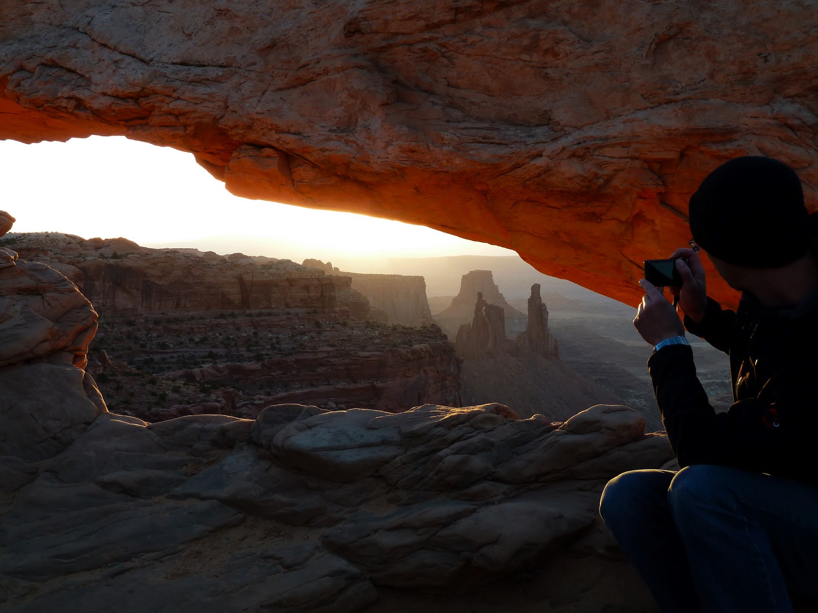
Sunday, April 21
I woke up a bit after 6 a.m. on my own Sunday, packed up all
my things efficiently, removed the slip of paper from the clip indicating I was
staying at the campsite, and drove to the crowded Mesa Arch parking lot. When I
had asked the ranger on Friday about the best sunrise spot in the park, she hadn’t
hesitated in telling me, “Mesa Arch.” Minutes later, after a short walk, I knew
why when I came upon dozens of photographers with their tripods out.
In front of them, the bright, early morning sun shone through
a small, rather horizontal arch. It was the perfect lens through which to
capture the sunrise, but I was still impressed by the number of people up early
on another cold Utah morning to take in the scene. I was no professional, but I
wiggled my way between a couple of the tripods to snap a few shots with my
handheld camera, gazed at the sun reflecting on the incredible rock structure
one last time, then headed back to the trail to complete the 0.5-mile loop.
Minutes later, I was on my way back to Salt Lake City.
Eight days.
90.9 miles hiked.
Countless incredible views.
Dozens of soaring ravens.
And hours upon hours of tranquility in an incredible place.
Southeast Utah, a gem of a place I’ll never forget.
Experience it for yourself!


